| |
|
 Landscaping Landscaping
|
|
 Basic directions Basic directions |
 Basic directions Basic directions |
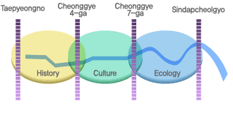
- Formation of a wider east-west green area linking Deoksugung(Palace), the Cheonggyecheon, the
Jungnangcheon(Stream), and the Hangang(River)
- Formation of a wider north-south green area linking Jongmyo(Royal Shrine), Seun Arcade, and
Namsan(Mt.)
- Preventing from flood
- Full utilization of available spaces and nature conservation
- Fostering a stable ecosystem by planting native plants and tress
- Securing channels for free movement of wild life
- Expansion of green areas
|
| |
| Basic plan |
- Formation of nature-friendly surroundings
- Securing the identity
|
| Focuses in design |
1) Terrace spaces on both sides of the stream
2) Formation of green areas on terrace spaces on both sides of the stream and sidewalks
3) Ecological consideration for biotopes, swamps, habitats for birds and fishes, and shallows
4) Walk paths, convenience facilities, and information offices
5) Wall paintings and other landmark items
|
| |
|
|
| Design direction |
| Design direction |
1) Easier access to the stream
2) Utilization of terrace spaces on both sides of the stream
3) Pipes are buried underground
4) Making the slope of the stream embankment softer
5) Stressing out the ecological conservation
|
| |
|
|
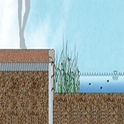
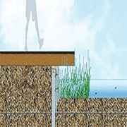
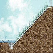
| Formation of high/low-water terrace spaces |
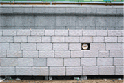
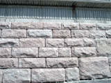
| High-water terrace spaces |
1) To make concrete walls look less gloomy
2) To employ traditional methods of building stream banks and retaining walls with stones
3) To enhance esthetic quality based on the elevation plan employing the golden section of 1:1.618
|
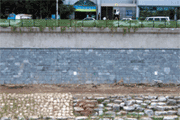
| Low-water terrace spaces |
1) Against floods
2) For the eco-diversity
3) For enhancing the esthetic quality of both sides of the stream
4) To consider local characteristics when adopting the shapes o the terrace spaces
|
| |
|
|
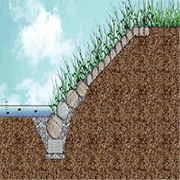
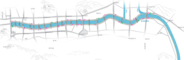
| Walk paths, roads on both sides of the stream, and access roads to the stream |
| Walk paths |
| - Design directions |
+ Emphasis made on an easier access to the stream, smooth movement of people, and convenience
in operation and management
+ Use of environmental-friendly materials. Consideration given to colors and feelings
+ Consideration also given to the operation and management requirements
|
| - Dimensions |
+ Length: 12.04km (6.62km for both pedestrians and management / 5.42km for pedestrians only)
+ Width: 3m for walks and 0.9~2.5m for sections for pedestrians only
|
| |
| Roads on both sides of the stream |
| - Design directions |
+ Making it easier to get access to both stores located along the stream and terrace spaces
+ Higher safety for vehicles and convenience of operation/management of relevant facilities and
need for emergency escape in case of flood
|
| - Dimensions |
+ For sidewalks: 3m in front of the buildings, 2.0m for parking the vehicles loading and offloading
goods, and 1.5m near the stream
+ For roads: Two 3m lanes where vehicles run at about 50km/hr
|
| - Design concept for roads on both sides of the stream |
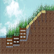
| Access roads |
| - Design directions |
+ Easier access to the stream
+ Prevention of floods
+ Consideration given to the entire esthetic quality of the area
|
| - Relevant structures |
| +Steps leading to the stream: 23 locations / Pedestrian access to the stream: 8 locations |
|
| |
|
| Bio-Tops |
| Design directions |
1) Construction of an environmental-friendly park
2) Building up some spaces where people can get their own hands-on experience of wild life
3) Natural formation of eco-friendly spaces
|
| |
| General status |
| - Overview |
1) Willow swamp : 3,520 square meters in total on 10 locations
2) Ecological parks: 17,074 square meters in total on 4 locations
3) Bird habitat: 12,589 square meters in 1 location
4) Fish habitat: 7,316 square meters in total on 3 locations
5) Shallows and marshes: 29 locations
|
| - Trees planted & Functions |
1) Willow swamp: willows and bulrushes, as well as rods and flat stones, designed to be habitats for
fishes, amphibians, and birds
2) Ecological parks: Briers, bulrishes, and willows designed to provide food for birds and some rest
areas as well.
3) Bird habitat: Marshes, sand bath areas, and puddles
4) Fish habitat: A fish way has been made in the place where the stream joins the
Jungnangcheon(Stream) constituting a refuge or a spawning ground for fishes
|
| |
|
|
| Greening of the stream |
1) Formation of a wider east-west green area and greening of the stream
2) Fostering a stable ecosystem by planting native plants and trees
3) Securing channels for a free movement of wild life for a higher eco-diversity
|
|
| |
|
|
|
|